

The Calanques are not a secret. They are one of the most visited natural parks in France, and for good reason — white limestone cliffs dropping straight into water so turquoise it looks like someone adjusted the saturation. ( I promise, I didn’t!)
After hiking both the Cassis and Marseille access routes myself, I realized most guides either make the Calanques sound effortless or terrifying. The reality sits somewhere in between.
This guide is for people who are in decent shape and walk regularly, but don’t train for hikes. It’s for those who want to see the Calanques without pretending the descent to En-Vau is easy. If you want to know what to expect, which path to choose, and if the beach at the bottom is worth it, this is for you.
This guide covers two entry points: Cassis in the east and Marseille in the west, each offering a different hiking experience. It also explains the boat and kayak options, since sometimes the best view is from the water.
At a glance
| Park name | Calanques National Park |
| Entry from Cassis | Port Miou → Port Pin → En-Vau, ~11km circular |
| Entry from Marseille | Calanque de Sugiton, 6.4km out-and-back |
| Difficulty | Moderate (En-Vau descent rates hard) |
| Booking required | Sugiton: yes in summer. Cassis trails: no |
| Best season | April–June, September–October |
| Essential gear | Hiking shoes, sun protection, water, snacks |

I’m Ersilia – architect and travel lover
📍 Based in Toulouse, I’ve been uncovering castles, villages & hidden gems for years — and I share the ones I truly love.
✨ Get my Paris Restaurants Map 🍷🥖
✨ Plus, download my Free Guide to the Loire Valley, Dordogne & Provence — with the best castles, villages, and slow travel tips I recommend
Want me to plan your trip? Details here
Which Calanques Hike Should You Choose?
| If you want… | Choose… |
|---|---|
| The most famous hike | En-Vau from Cassis |
| The easiest hike | Sugiton |
| The best swimming | En-Vau |
| The best views with less effort | Sugiton viewpoint |
| No hiking | Boat tour (like this one from Marseille) |
| Something active but easier | Kayak |
Before You Start: The Practicalities
Access Can Be Restricted
The Calanques National Park closes trails during periods of high fire risk — typically in summer from late June onward, sometimes earlier depending on conditions. Before you go, check the official closure map at bpatp.paca-ate.fr. This is not optional in July and August. Trails can close with little warning and the restrictions are enforced.
For full park regulations and trail information: calanques-parcnational.fr
Sugiton Requires a Booking in Summer
The Calanque de Sugiton, accessed from Marseille, is one of the most heavily visited inlets in the park and has suffered significant erosion as a result.
During peak season the National Park limits visitor numbers — access requires a free reservation made in advance. No booking, no entry. Do this before you travel.
The Cassis trails — Port Miou, Port Pin, En-Vau — do not currently require booking. But arrive early in summer regardless; the paths get busy by mid-morning.

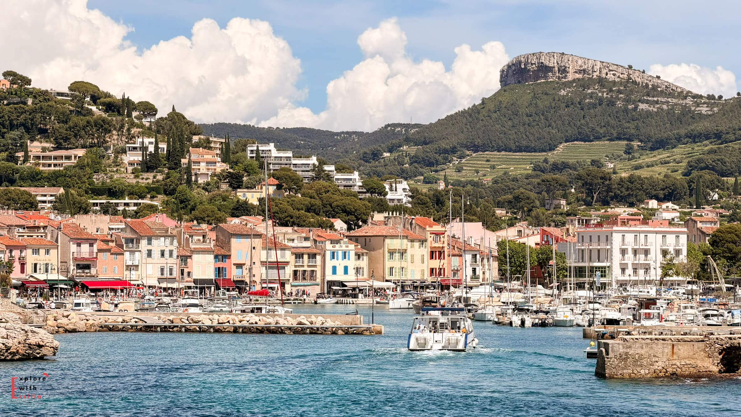
Where to base to hike the Callanques
Marseille and Cassis are the most obvious choices to stay in for hiking the Callanques. Ofcourse, they offer a completely different experience.
A lesser known (and considered) place is La Ciotat, another coastal town situated after Cassis.
I would base in Marseille for a city trip and I’d visit the Callanques by bus. For a longer, coastal experience, I’d go for Cassis or La Ciotat. Cassis is more charming but more crowded and expensive, while La Ciotat feels more young and offers a better value for price.
I compared all these 3 bases in detail, so if you’re still on the fence about where to stay between Marseille, Cassis and La Ciotat, read that guide. It includes hotel options too and directions on how to visit the Callanques from staying there.
What to Wear and Bring
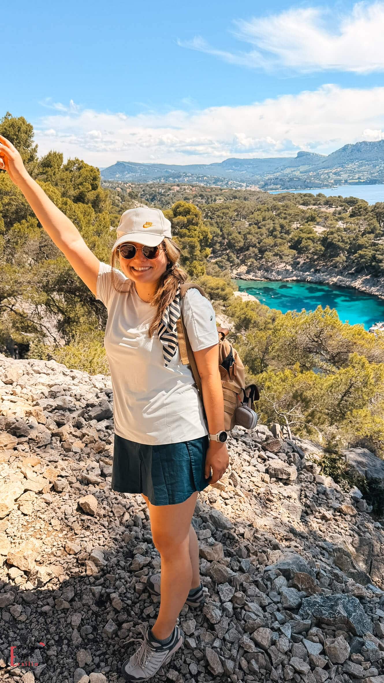
Wear hiking shoes or trail runners, not sandals or regular trainers. The limestone can be slippery, and the descent to En-Vau beach is steep with loose rocks. Good grip is important. Several recent hikers have pointed this out, so I consider it essential.
Besides shoes, bring at least 1.5 liters of water per person, sunscreen, a hat, and snacks. There are no shops or water sources on the trails. In June, the sun reflecting off the white limestone feels much hotter than you might expect.
Route 1: From Cassis — Port Miou, Port Pin and En-Vau
Can a reasonably fit traveler do this hike? Yes, at least the first part. The hardest part it’s the descent to En-Vau beach. Honestly I would skip that part.
Distance: 11.1km circular
Elevation gain: 499m
Difficulty: Moderate overall; the descent to En-Vau beach is hard
Booking: Not required
Terrain: Uneven limestone surfaces, stone steps, exposed ridgeline sections with little shade, one steep loose-rock descent to the beach
This is the classic route from Cassis, taking you through three calanques in a row. Each one is different and each is worth the walk.
Getting to the Trailhead
The trail begins at the edge of Cassis and is easy to reach on foot from the town center. If you’re staying in Cassis, you won’t need a car, which is a big plus.
Leave early, before 9am during the busy season, to enjoy the first part of the path with fewer people.
Port Miou
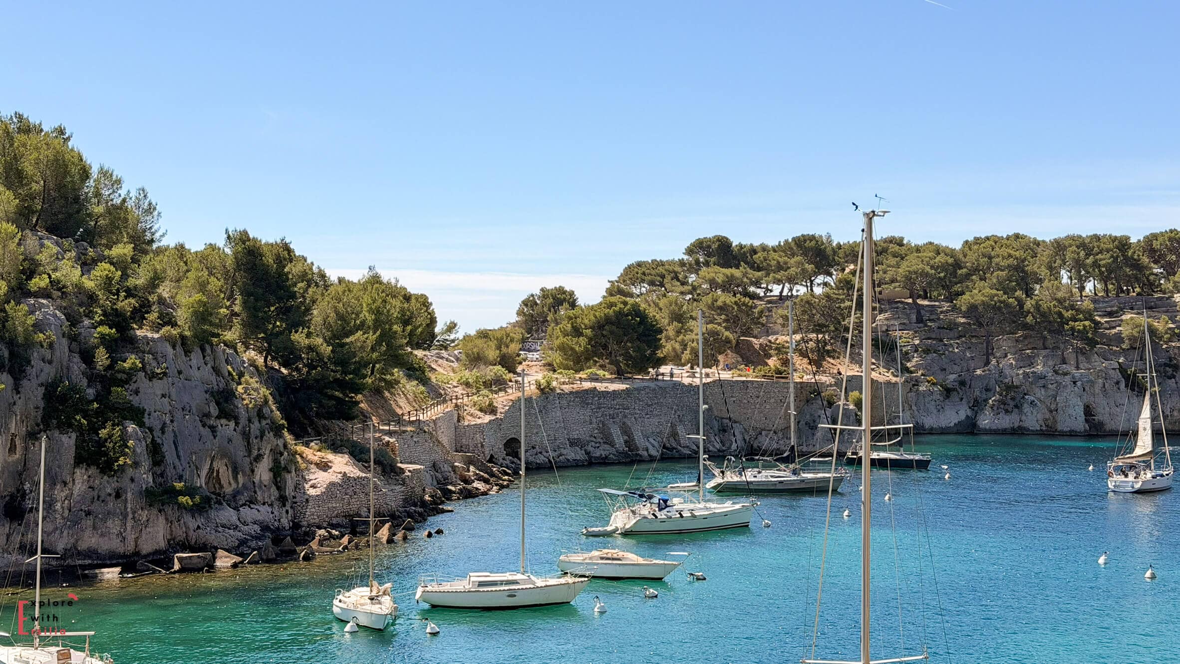

The first calanque is Port Miou, and it’s the easiest to reach. It’s a long, narrow inlet with moored boats, calm water, and white cliffs on both sides. It feels more like a harbor than a swimming beach, but walking along its edge is beautiful and gives you a sense of how big these inlets are.
That’s why I don’t suggest Port Miou as a beach destination. It’s too far to carry beach gear, and there isn’t much space. Think of it as a highlight along the hike, not the main goal.
Port Pin

From Port Miou, the path climbs a bit before dropping down to Port Pin. This is a real beach calanque, with a small sandy shore, pine trees by the water, and cliffs on three sides. The walk is mostly flat with some stone steps and is manageable for most people with good shoes.
Many locals stop at Port Pin. They bring lunch, swim, and spend the afternoon there. In May, it was already crowded, and in July it will likely be very busy. If you want to swim and don’t plan to do the full hike, Port Pin is a great place to stop.
But it’s AFTER Port de Pin that the views start getting incredible! So enjoy your pause here, but please keep going after that !
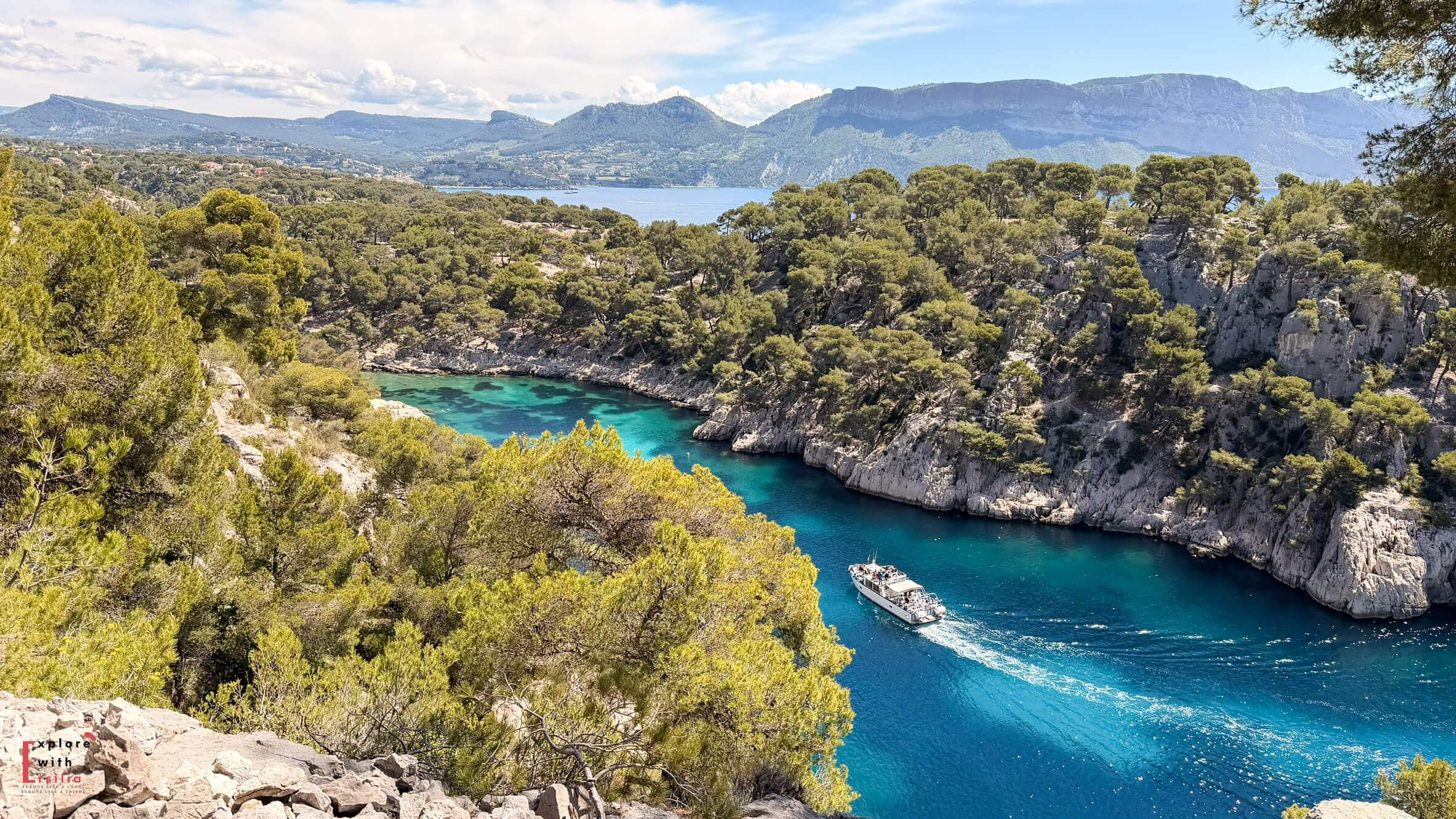
The Fork: Which Path to En-Vau
After Port Pin, the path splits. The right route is shorter and gets you to En-Vau beach more quickly. The left route is longer but first takes you to the clifftop viewpoint above En-Vau.
Choose the left path. The viewpoint is one of the most dramatic sights in the Calanques.


From above, you look down into En-Vau, with sheer white walls dropping to a small turquoise beach far below. This view is very different from what you see at sea level, and you won’t get it on the shorter route.
The Descent to En-Vau Beach
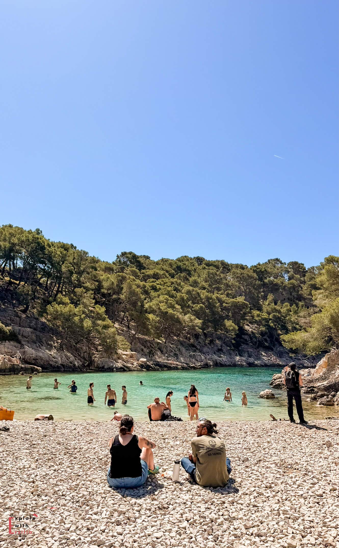
After the viewpoint, the path drops steeply to the beach. This is the hardest part of the whole route, with loose stones, a steep slope, and slippery limestone in some spots. Going down is hard, and coming back up is even harder.

I’ll give you my honest take: the beach at En-Vau is beautiful, but it is very crowded in season. We went down in early May and barely found space to sit. The water is clear and the swimming is good, but you are sharing it with a lot of people.

If I did it again, I’d have my picnic at the viewpoint instead of the beach, enjoy the view in peace, and save my energy for the return. Still, several hikers who went all the way down said the swim was worth it, so it depends on what matters most to you. Just be aware of what the descent involves.

The Return: Go Clockwise
If you’re doing the full circular route, go clockwise after Port Pin. This means taking the viewpoint path toward En-Vau instead of the direct descent. The uphill section on the other side is tough in direct sun and is easier to handle earlier in the hike than at the end.
Key facts for this route:
- Rated 4.8 on Alltrails from hundreds of reviews
- Officially moderate; the En-Vau descent section rates hard
- Limestone is slippery, so hiking shoes are essential.
- Not recommended for young children on the En-Vau descent
- Dogs allowed but need to be capable on steep terrain
Route 2: From Marseille — Calanque de Sugiton
Distance: 6.4km out-and-back
Elevation gain: 275m
Difficulty: Moderate
Booking: Required in summer. Book at calanques-parcnational.fr
Terrain: Well-marked path with some rocky sections, a concrete descent near the bottom, slippery limestone near the water
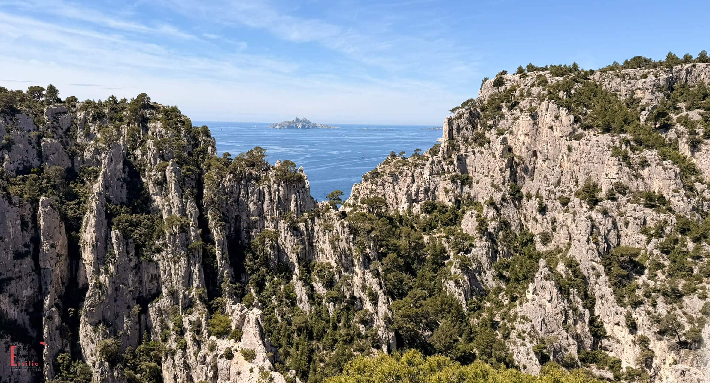
Sugiton is the most famous calanque you can reach from the Marseille side, and it shapes most people’s image of the Calanques: two small coves, sheer white walls, and the Torpilleur islet rising from the water between them.
Getting There

Head to the Luminy university campus on the southern edge of Marseille. There’s a large parking lot there, but in summer it fills up fast — arrive before 9am or take the bus from central Marseille. From the campus, the walk to the Sugiton viewpoint takes about 30 minutes on a well-marked path.
On the way, you pass the Sugiton Pass — worth a short detour to the viewpoint over Morgiou Cove, another inlet in the park, before continuing down.
The Descent to Sugiton


The descent from the pass to the calanque begins on a footpath and continues along a slightly steep concrete section. At the final bend — still high above the water — Sugiton reveals itself: the two coves, the islet, the blue below. It’s one of those views that actually lives up to the photographs.
The path down is manageable but requires attention, especially on the limestone sections. Hiking shoes rather than sandals, as on the Cassis route.
The Beach

Sugiton is small. The booking system is there because space is limited and overcrowding was causing erosion. With reservations, the experience is much better than before. The beach feels busy but not overcrowded.
The water is exceptional. Clear, deep blue-turquoise, cold even in summer. If the descent and the swimming are the main event for you, Sugiton delivers.
The Viewpoint Alternative

If you don’t want to go down to the beach, or if the descent feels like too much, the viewpoint from the pass above Sugiton is worth the trip on its own. From up there, you can see the whole coastline and the calanques below. It’s one of the best views in the park.
Alternatives to Hiking: Boat Trips and Kayak
Not everyone wants to hike 11km in the sun to reach a calanque. The good news is that the view from the water is often even better. You see the cliffs from below, can reach inlets the trails miss, and avoid the tough descent to En-Vau.
Boat Trips from Cassis, La Ciotat or Marseille

Boat trips leave from Cassis, La Ciotat and Marseille port and visit different numbers of calanques depending onhow long the trip is. The short one covers 3, the medium covers 9, and the longest covers all 13.
recommend the medium or long trip. Seeing 9 calanques from the water is much more impressive than just 3, and the full circuit shows you the park’s scale in a wayt no single hike ca.h.
I honestly regret not taking a boat trip when we were in Cassis. After hiking, sitting on a boat and seeing the path from the sea seemed like the perfect way to finish the experience. If you only have one day, the hike is more active and memorable. If you have two days, try both.
Kayak Tours

A kayak is theperfect size for exploringr the Calanques. You canentero the narrowest inlets, paddleclose to the cliffs, and reach spots that hiking trails and bigger boats can’t accessh. I saw peoplekayakings at Calanque de Figueroles in La Ciotat and immediately wished had tried it.t.
If you’re in decent shape and want something more active than a boat tour but more personal than hiking, a guided kayak tour is the best way to see the Calanques. Book ahead, as spots fill up quickly in peak season.
Which Option Is Right for You?

You want the full experience and you’re reasonably fit: Do the Cassis circular route — Port Miou, Port Pin, En-Vau viewpoint. Skip the descent to the beach unless you specifically want the swim and are comfortable on steep terrain.
You want to swim in a calanque without a major hike: Sugiton from Marseille is shorter and well-marked. Book your slot in advance. Go early.
You want the views without the physical effort: The viewpoint above Sugiton from the Luminy campus is 30 minutes of easy walking and gives you one of the best panoramas in the park.
You want to see the most calanques in one day: Take the boat from Cassis. The medium or long option covers more ground than any single hiking trail.
You want something active and intimate: Kayak tour. Book it.
Best Time to Visit
April and May — the best window. Trails are open, crowds are manageable, wildflowers on the limestone, water still cool. My recommendation if you can plan around it.
June — still good but getting busy. Go early in the day and check fire closure maps before leaving.
July and August — beautiful and very crowded. Fire closures possible. Sugiton booking essential. Arrive before 9am everywhere.
September and October — excellent. Summer crowds gone, water at its warmest, trails in good condition. Second-best window after May.
November to March — trails open but some sections can be wet and more slippery than usual. Quieter and a different kind of beautiful. Check conditions before going.
Quick Answers
Are the Calanques difficult to hike?
The main Cassis circuit is officially rated moderate, but the descent to En-Vau beach is hard — steep, loose, and tough on the knees both ways. If you’re in normal walking shape and wearing proper shoes, the rest of the route is manageable.
Do you need to book to visit the Calanques? For Sugiton
Do you need to book to visit the Calanques?
Do you need to book to visit the Calanques? For Sugiton (from Marseille), yes — free booking required in summer at calanques-parcnational.fr. For the Cassis trails, no booking currently required, but check fire closure maps before going.
Can you swim in the Calanques?
es — the beaches at Port Pin, En-Vau, and Sugiton all have swimming. The water is cold even in summer and exceptionally clear.
How long does the Cassis hike take?
The full 11km circular route takes between 3.5 and 5 hours depending on your pace and how long you stop. Add time for swimming if you descend to the beach.
How to Fit the Calanques Into Your Provence Itinerary
The Calanques work best when they’re part of a wider day rather than a standalone objective. Here’s how I’d structure it depending on where you’re based.

Staying in Cassis
Cassis is the best base, as it allows you to start the hike early — at the trailhead by 8:30am.
Do Port Miou, Port Pin, and the En-Vau viewpoint at your own pace.
Return to Cassis by early afternoon, change, have lunch at one of the restaurants in the back streets (book ahead).
If you have energy left, drive the Route des Crêtes toward La Ciotat in the late afternoon — the light on the limestone from that clifftop road is worth the extra hour.
Staying in Marseille
Morning Sugiton hike from Luminy — book your slot in advance, arrive before 9am, be back in the city by early afternoon.
Spend the afternoon in the Panier neighbourhood, the old port quarter with narrow streets, street art, and good coffee. End the evening at Notre-Dame de la Garde, the basilica on the hill above the city — the view over Marseille and the coast at sunset is one of the best in Provence.
Staying in Aix-en-Provence
Aix is about 40 minutes from Cassis by car and is a perfect base to visit Provence.
A day trip is perfectly feasible: drive to Cassis in the morning, do a shorter version of the hike (Port Miou and Port Pin, skip En-Vau), have lunch at the port, and return via the Route des Crêtes through La Ciotat.
You’ll be back in Aix by early evening. No special logistics beyond the parking — use the main lot at the entrance to Cassis and leave the car there for the day.
Other topics you might like


