

I didn’t expect Tenerife to be a hiking paradise.
I always heard about Madeira for hiking, but Tenerife? Hardly anyone mentions it.
That was a mistake. In 9 days, we fit in 4 full hiking days, and honestly, we wished we could have stayed longer to do even more.
The variety of landscapes is wild. One day you feel like you’re on Mars at Teide, the next you’re in valleys that look like Sri Lanka, and then you’re hiking along dramatic coastal cliffs that bring Hawaii to mind.
This guide shares every hike we did in detail, plus extra trails recommended by locals. You’ll find GPS coordinates, difficulty ratings, packing tips, and honest opinions about which hikes are really worth your time.

THIS POST IN SHORT
- Best overall hike: Masca Trail (10.3km, moderate-hard, 4.5 hours)
- Most dramatic coastal views: Cruz del Draguillo from Benijo (10.4km, hard, 3 hours)
- Best in Teide: Roques de García (4.3km, easy-moderate, 1.5 hours)
- Best easy warm-up: TFS 004 La Quinta – Boca de Paso (5km, moderate, 2 hours)
- Most challenging: Masca plus combining three trails (don’t do this; just go directly to Masca)
- Essential gear: Water shoes, sun protection, plenty of water, AllTrails app downloaded offline
Practical links:
- AllTrails app: AllTrails
- Offline maps: Download before you go
- Car rental: DiscoverCars (essential for reaching trailheads)
- our 9 day itinerary in Tenerife, to help you plan your trip

I’m Ersilia – architect and travel lover based in France
I help English-speaking travelers plan meaningful trips across Europe, mixing iconic sights with hidden gems and authentic local experiences, all based on places I’ve personally explored.
✨ Browse my Europe guides
✨ Or discover my France travel resources for deeper local insight
Want me to plan your trip? Details here
Planning Your Tenerife Hikes: What You Need to Know
Best Time to Hike
Morning: Start as early as possible, especially for exposed trails. We usually started around 8-9 AM. Less heat, better light for photos, fewer people.
Afternoon: Some trails like Roques de García are great in the late afternoon for sunset, but bring extra layers because the temperature drops quickly.
Avoid midday: We were there in June and the sun was brutal on exposed trails. We learned this the hard way.
What to Bring
Essential:
- Water (bring more than you think you’ll need; we brought 2-3 liters per person)
- Sun protection (hat, sunscreen, sunglasses)
- Water shoes or good hiking boots (some beaches/trails have hot black sand or pebbles)
- Snacks (there are very few places to buy food on trails)
- Offline maps downloaded on AllTrails
Nice to have:
- Trekking poles (helpful on steep descents like Masca)
- Light jacket (weather changes fast, especially near Teide)
- Camera (every trail is photogenic)
Difficulty Ratings in this Article
Easy: Flat or gentle inclines, well-marked, suitable for most fitness levels, under 5km
Moderate: Some elevation gain, may include rocky sections, 5-10km, requires reasonable fitness
Hard: Steep inclines/descents, rocky terrain, 10km+, exposed sections, requires good fitness and proper shoes
Where to stay in Tenerife for Hiking
The best hikes in Tenerife are:
- in the North, in the Anaga mountains
- in the Ouest in the Parco Rural de Teno
- in the Teide National Park
There are also some lesser-known hikes in the South.
But if your main goal is to hike in Tenerife, I would recommend staying in the North, but somewhere central, like Puerto de la Cruz or even Garachico.
If you mainly want to hike in the Teide National Park, you can stay in Vilaflor, the last village before entering the National Park.
All the hikes in this article were done while based in Costa Adeje, but that meant we had to drive at least 1 hour before and after each hike.
While driving was not a problem for us, hiking in Tenerife is definitely easier if you base yourself in the North.
On the map below, I put the 3 most important hikes so you can easily see where they are located compared to Puerto de la Cruz.
My favourite hotels in the North of Tenerife


See available hotels in the North of Tenerife
The Best Hikes in Tenerife (Detailed)
1. Masca Trail: The Dramatic Valley Descent
 I actually loved that you couldn’t see where the trail ended
 the view above Erjos, the only time we saw Mount Teide on this hike
- Outdoor restaurant terrace at Mirador La Cruz de Hilda


Our rating: ⭐⭐⭐⭐⭐ (Best hike in Tenerife)
Trail name: Santiago del Teide – Mirador Cruz de Hilda – Masca
Distance: 10.3 km
Elevation gain: 353 m
Duration: 4 hours 30 minutes (moving time: 3h27)
Difficulty: Moderate to Hard
GPS start point: Santiago del Teide parking
AllTrails link: the way we did it
Why This Hike Is Incredible
This was the best hike we did in Tenerife, hands down.
You start with views of Teide, then move on to the mountains, and finally the ocean. The scenery keeps changing.
The last part, descending into Masca village, was my favorite one, with steep cliffs on both sides and the village perched on the mountainside.
Where to start
We took the bus from Santiago del Teide to Erjos, then hiked from there to Masca. I wouldn’t recommend doing this, although the views were beautiful.
We had to combine 3 different trails because there’s no direct hike from Erjos. The first section was incredibly difficult and not well marked.
Do this instead: Start in Santiago del Teide and head to Masca. Much easier, still spectacular. Just pay attention that they are working on a tunnel through the mountain, a part of the hike is deviated. Make sure to follow the marked route.
The highlight is Mirador Cruz de Hilda, an amazing viewpoint where we stopped for a break and enjoyed smoothies and ice cream.
You can park here if you don’t want to do the full hike and just want to enjoy the views.
Practical Details
Parking: Free parking in Santiago del Teide with enough spaces along the street. We parked there, took the bus to start in Erjos, then took the bus back from Masca.
Bus: Check the schedules, as there are only a few buses per day between Santiago and Masca. Make sure to end your hike before the last one.
What to bring: Water and food. The only place to buy something is at Mirador Cruz de Hilda, near the end, or in the village itself.
Best time: Start as early as you can. We started in the late morning and regretted it because it was hotter and there were more people when we arrived in Masca.
Tricky parts: Some rocky sections, but nothing technical. The challenge is the length and elevation changes.
Who it’s for: Anyone with reasonable fitness. Not suitable for young children or people with knee problems (due to the steep descent).
Our Honest Take
Loved: The variety of landscapes, Mirador Cruz de Hilda stop, arriving in Masca village from above (spectacular), not too crowded along the way
Would change: Start from Santiago del Teide directly instead of the Erjos detour
Skip if: You’re not comfortable with 4+ hour hikes, you have knee issues, or you’re traveling with young kids.
2. Cruz del Draguillo from Benijo: Dramatic Coastal Cliffs

- the first part of the hike
- a cute house you cross on the way
- you can get to this view by car+ 5 minutes of walking
- view over Playa de Benijo from above
- Taking in the epic cliffs of Anaga


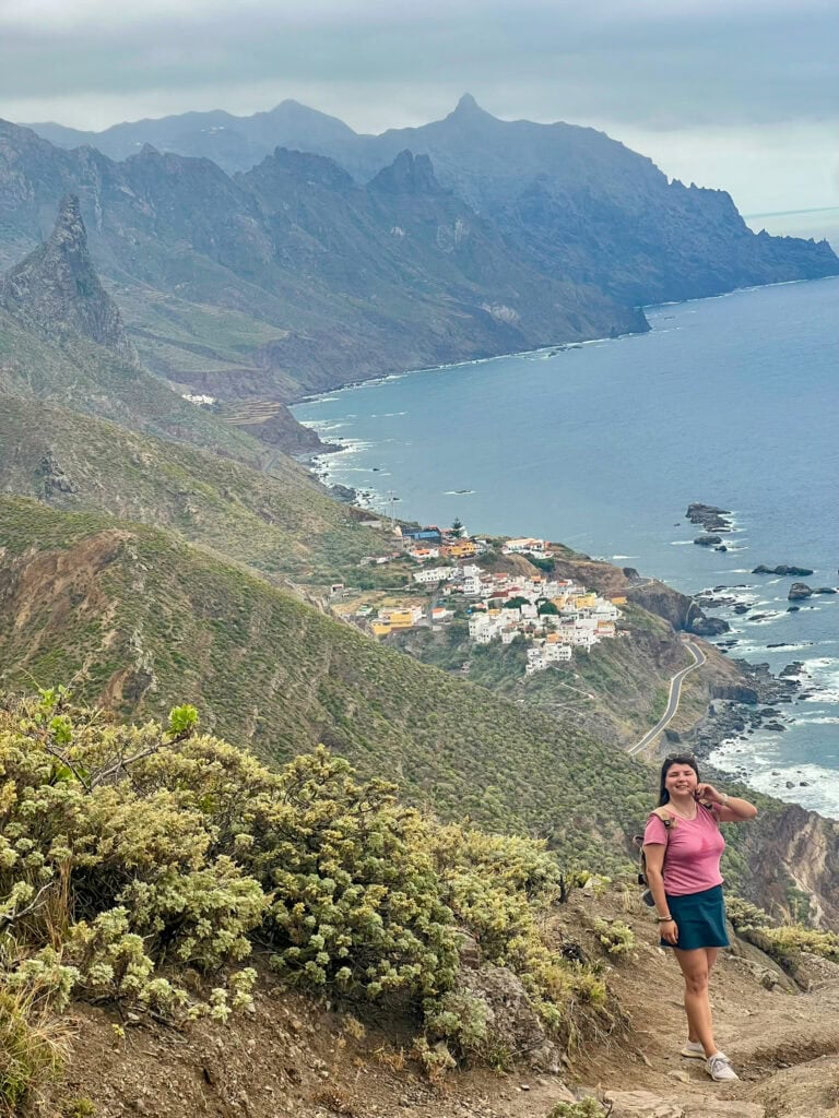

Our rating: ⭐⭐⭐⭐⭐ (Most dramatic views)
Trail name: PR-TF 6.3 Benijo – Cruz del Draguillo
Distance: 7 km
Elevation gain: 740 m
Duration: 3 hours (moving time: 2h15)
Difficulty: Hard
GPS start point: Benijo beach area
AllTrails link: the way we did it
The coast here is completely different from anything else in Tenerife.
It’s rough, with sharp ridges. It looks like Hawaii (at least, that’s how I imagine it, since I’ve never been). The trail follows dramatic cliffs with the Atlantic crashing below. It feels raw, wild, and stunning.
Where to start
The hike starts from Benijo, a tiny coastal area in the Anaga Mountains. The first part is extremely hard. It’s steep, rocky, and exposed. We both found it challenging.
The views are incredible for the first 15 minutes, then you just climb and climb with nothing new to see.
The trail climbs to Cruz del Draguillo,and it’s there that everything changes. The highest point offers panoramic coastal views that go on forever.
On a clear day, you can see for miles along the northern coast.
Practical Details
Parking: Small parking area at Benijo. Not enough spaces. Someone let us park in their garden, but we were seriously worried we wouldn’t be able to. Arrive early or be prepared to wait.
Driving warning: If you think driving to Masca is tough, Benijo is even more challenging. The mountain roads are narrow, with sharp turns and steep drops. I even had to close my eyes a few times (I wasn’t driving!!).
Only try this drive if you’re confident on mountain roads.
What to bring: Water, snacks, sun protection. No facilities anywhere.
Best time: Early morning. Less heat, better light. We did this on our last full day and were exhausted but glad we pushed through.
Tricky parts: The first section is steep and rocky. Proper hiking shoes are essential. Not suitable without good fitness.
Who it’s for: Experienced hikers, people comfortable with challenging terrain, and anyone seeking dramatic coastal views.
Our Honest Take
Loved: The raw, wild coastline, feeling completely away from tourist Tenerife, the sense of accomplishment
Challenging: The driving to get there, the steep first section, and the limited parking
Skip if: You’re not confident with a bit more challenging hikes, you don’t have proper hiking shoes, or you’re uncomfortable with mountain driving.
3. Roques de García (Teide National Park): Mars on Earth
- Hiking around Roque Cinchado with Mount Teide towering behind
- When you literally can’t carry the weight of your vacation plans
- Roques de Garcia hike in Teide


Our rating: ⭐⭐⭐⭐⭐ (Best easy/moderate hike)
Trail name: Roques de García
Distance: 4.3 km (circular)
Elevation gain: 194 m
Duration: 1 hour 45 minutes (moving time: 1h26)
Difficulty: Easy to Moderate
GPS start point: Mirador de La Ruleta parking lot (near Parador de Las Cañadas del Teide)
AllTrails link: the way we did it
This is the hike that convinced me Teide is worth dedicating an entire day (or two) to.
The landscape is Mars-like, with red and brown volcanic rocks, zero vegetation, and dramatic rock formations called “roques”. Pico del Teide (the actual volcano) looms in the background.
It’s surreal. You genuinely feel like you’re on another planet.
Where to start
This is a circular trail that starts at the Mirador de los Roques parking lot.
The path is well-marked and mostly flat for the first half, making it accessible even if you’re not in great shape.
The second half gets a bit harder with some elevation gain, but nothing extreme. Even if you only do the first 30 minutes to 1 hour and turn back, the views are worth it.
We hiked this trail in the late afternoon and evening to catch the sunset, which was incredible. The light on the volcanic rocks turned them gold, red, and purple. It was unforgettable.
Just make sure to get back before the night, the returning hike is dangerous to attempt during darkness.
Practical Details
Parking: Large free parking lot at Mirador de los Roques. Gets busy midday but usually has space.
What to bring: Water, jacket (gets cold fast when sun goes down), camera.
Restaurant: Parador de Las Cañadas del Teide is the main restaurant in the park, near the trailhead. Good for lunch or coffee.
Best time: Late afternoon for sunset lighting, or early morning for fewer people and cooler temperatures.
Tricky parts: Some rocky sections, but mostly manageable. Altitude can affect some people.
Who it’s for: Everyone. Families, older travelers, anyone wanting Teide experience without extreme difficulty.
Our Honest Take
Loved: The Mars-like landscape, accessibility, sunset lighting, how peaceful it felt
Would change: Nothing—this hike is perfectly designed.
Skip if: You’re not interested in volcanic landscapes (but honestly, who isn’t?)
4. TFS 004 La Quinta – Boca de Paso: Wildflowers & Coastal Views


Our rating: ⭐⭐⭐⭐ (Best warm-up hike)
Trail name: TFS 004 La Quinta – Boca de Paso
Distance: 5 km (circular)
Elevation gain: 178 m
Duration: 2 hours (moving time: 1h43)
Difficulty: Moderate
GPS start point: Parking lot near Ermita de Santa Margarita, La Quinta village (near Taucho, Adeje)
AllTrails link: the way we did it
This was Day 2 of our trip, a way to get acquainted with the island and see if Tenerife hiking was going to be good.
Verdict: We began to realize that Tenerife was going to be a very good surprise.
Where to start
This loop trail begins in La Quinta village, near Taucho.
The first thing you see, is this cute chapel with a single palm. I loved how it looked.
You will park near it, and start your 5 km walk here.

It continues with a gentle ascent through an open pine forest, then descends to the spectacular Boca del Paso viewpoint, high above the main tourist centers of the south coast.
The views are incredible, as you can see Costa Adeje, Playa de las Américas, and the ocean stretching out forever.
Wildflowers were blooming when we visited in late May and early June. Even in winter, you’ll spot flowers along this trail. Much of the pine forest still shows signs of past fires, but it has fully recovered. It’s beautiful in a resilient way.
Practical Details
Parking: Easy to park near Ermita de Santa Margarita.
What to bring: Water, a sun hat (not much shade), a camera for the viewpoint over the coast.
Crowds: We saw only one family. Come early for even more solitude.
Best time: Morning or late afternoon. Midday sun is intense.
Tricky parts: Some exposed sections with little shade. The viewpoint is high and can be windy.
Who it’s for: Anyone with moderate fitness, families with older kids, people wanting a shorter hike with great views.
Our Honest Take
Loved: The wildflowers, Boca del Paso viewpoint, not crowded, close to Costa Adeje
Challenging: Limited shade, some steep sections but easy overall
Skip if: You’re only doing one hike in Tenerife (choose Masca or Teide instead)
More Great Hikes in Tenerife
Based on local guidebooks and recommendations, here are additional trails worth considering:
Barranco del Infierno (Hell’s Gorge)
Distance: ~6 km round trip
Difficulty: Moderate
Location: Near Adeje
One of the most popular hikes in southern Tenerife.
A gorge walk through dramatic canyon walls ending at a waterfall.
Requires advance booking (with timed entry slots) and has a daily visitor limit.
Great for families.
Anaga Rural Park: Sendero de los Sentidos
Distance: Various trails, 5-15 km
Difficulty: Easy to Moderate
Location: Anaga Mountains (northeast)
Lush green forests, completely different from the rest of Tenerife.
Trails wind through ancient laurel forests (laurisilva). It can be foggy and cool. Beautiful, peaceful, less crowded.
Punta de Teno Coastal Walk
Distance: ~5 km one way
Difficulty: Easy
Location: Northwest tip of Tenerife
You’ll see dramatic coastal cliffs, a lighthouse, and wild ocean views.
The road to Punta de Teno is often closed to cars, so check before you go.
It’s usually best to visit by bus or with an organized tour.
Montaña Amarilla (Yellow Mountain)
Distance: ~3 km
Difficulty: Easy
Location: Near Golf del Sur (south)
Short coastal hike around a volcanic cone. Good for sunset. Easy parking, family-friendly.
Chinyero Volcano Trail
Distance: ~5 km
Difficulty: Easy
Location: Near Santiago del Teide
Walk around Tenerife’s most recent volcanic eruption site (1909). Black volcanic landscapes, pine forests. Easy and accessible.
Masca Gorge Descent (to the beach)

Distance: ~5 km one way (descent)
Difficulty: Hard
Location: Masca village
This is the well-known hike from Masca village down to the beach through the gorge. You need a permit, and it’s often done as a tour that includes a boat ride back from the beach.
We didn’t do this one, but it’s supposed to be amazing, similar to hiking through Samaria Gorge in Crete. It’s a once-in-a-lifetime experience if you’re up for it.
Book ahead: Tours include the hike down and boat back up. You will aslo get the permit that is mandatory to do the hike. As places are limited, due to the limited number of persons that are allowed into the Gorges, you have to book months in advance. Check availability here.
Essential Hiking Tips for Tenerife
Download AllTrails Offline
Cell service is spotty in mountains. Download your trail maps before you leave your accommodation. We used AllTrails Pro—worth every penny.
Weather Changes Fast
We’d have 25°C and sun in Costa Adeje, then drive to the north or Teide and hit fog or cold. Always bring layers.
Water Shoes Are Essential
Black sand beaches get incredibly hot. Rocky trails have pebbles. Water shoes saved us multiple times.
Start Early
Heat builds fast. Parking fills up. Trails get busier. Starting at 8-9 AM made every hike better.
Respect Trail Limits
Some trails require permits or have daily visitor limits (like Barranco del Infierno, Teide cable car summit). Book ahead. Don’t try to sneak in—fines are real.
Drive Carefully
Mountain roads to trailheads (Masca, Benijo especially) are challenging. If you’re not comfortable, consider guided tours instead.
Know Your Limits
Some trails look easy on paper but are challenging in heat and altitude. We’re in decent shape and still found Benijo exhausting. Be honest about your fitness level.
Which Hike Should You Choose?
If you only do one hike: Roques de García in Teide. Accessible, stunning, uniquely Tenerife.
If you do two hikes: Add Masca Trail. These two cover volcanic landscapes and mountain valleys.
If you do three hikes: Add Cruz del Draguillo from Benijo for dramatic coastal views.
If you have more time: Add La Quinta for an easy warm-up and Barranco del Infierno for waterfall experience.
For families: Roques de García, La Quinta, Montaña Amarilla.
For serious hikers: Masca, Benijo, Masca Gorge descent to beach, Anaga forest trails.
For best photos: Masca Trail, Roques de García, Benijo coastal views.
Final Thoughts
Tenerife surprised me completely with its hiking.
I arrived expecting beaches and a volcano, but I left completely obsessed with the trails. They’re so diverse, accessible, and truly spectacular.
If you’re even remotely interested in hiking, don’t skip this. Rent proper shoes if you don’t have them. Download AllTrails. Block out at least 2-3 days for hiking in your itinerary.
The trails here are as good as those in more famous hiking spots. Unlike some places, you don’t need to be an extreme athlete to enjoy them. There’s something for every fitness level.
Would I come back to Tenerife just for the hiking? Absolutely.
Next time, I’d dedicate even more days to it. Maybe a full week of nothing but trails. The beaches can wait.

author page / EDITORIAL POLICY PAGE
Hi, I’m Ersilia

Toulouse, France

Originally from Romania

English & French Content
As a Romanian expat living in the heart of southern France, I guide English speakers to discover authentic French experiences without the language barrier. My unique perspective as both a local and an expat allows me to share insider tips, cultural insights, and practical advice that you won’t find in typical guidebooks.
My Expertise:
- French life and culture navigation
- Hidden gems across French regions
- Eastern vs Western European perspectives
- Local insights and practical travel tips
Blog Socials
Personal Pages
Other topics you might like


